In the 13th Century Fazakerley was one of the Walton town fields. It was a rural area dotted with farms and large houses until it began to industrialise in the 19th and 20th centuries.
From the Victoria Country History: Fazakerley is separated from Walton by the Fazakerley, or Tue Brook. It is separated from West Derby by the Sugar Brook, up to where it is spanned by the Stone Bridge. The lowest point in the landscape is where these two brooks join, on the border with Kirkby. The landscape at the turn of the 20th Century was flat and featureless.
Fazakerley began life as a town field of Walton, which probably led to it’s name (from the Anglo-Saxon meaning the border field with the clearing in a wood). The boundary of the township was party formed by the Tue Brook (after which an area of Liverpool further south is named), and Fazakerley Brook. Walton lies to the west, and the old boundary of the Walton Hall Estate also forms part of Fazakerley’s boundary.
Recommended sources
Website: https://fazakerleyhistory.blogspot.com/ There doesn’t seem to be a website dedicated to Fazakerley history, but this blog (updated until 2008) has a lot of information on the area, though concentrating on the hospital.
Book: A Brief History of Fazakerley by the Fazakerley Local History Group. Fazakerley Through the Ages was published in 1987 by the Fazakerley Local History Group. It has reminiscences by residences and plenty of old photos, plus the history itself is well worth a read.
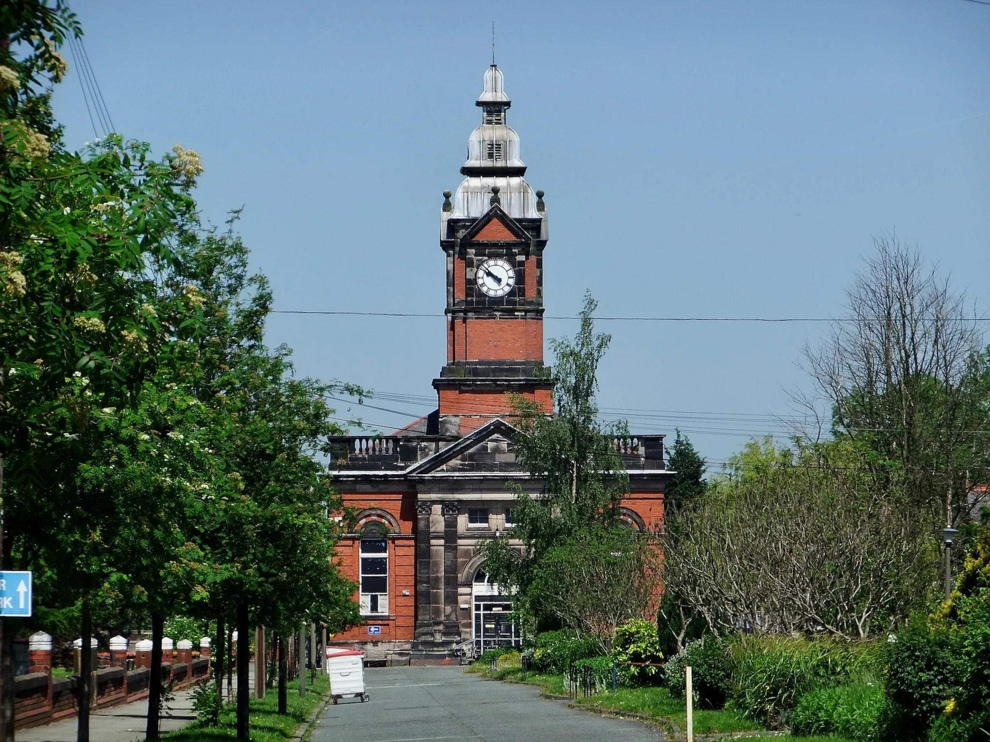
Fazakerley c.1900
Use the slider in the top left to change the transparency of the old map.
The Fazakerley Family
The Fazakerley family were the main landowners in the area, and took their name from the township. They sold a lot of their land to the Liverpool Corporation when the city needed new land for development. Fazakerley Street near Old Hall Street in Liverpool’s city centre is named for the former owners of the land that the road was built on. The Fazakerleys also owned Spellow House (on a site near the modern Spellow Lane).
The home of the Fazakerley family, Fazakerley Hall, stood near Fazakerley Hall Lane, on Fazakerley Brook. Fazakerley House was a three storey farmhouse built in 1749. It stood at the end of a long drive which, after the redevelopment of the area, became Fazakerley Road. By the 20th century the house belonged to one Ms. Evered, a relation of the Fazakerley family by marriage, commemorated by Evered Avenue.
Health Care
These days Fazakerley is known for its modern hospital, but the roots of healthcare in the area go back a long way.
Fazakerley Cottage Homes
One of Fazakerley’s characteristics is as the location for a series of healthcare institutions. This part of the township’s history started in 1889 with the opening of the Fazakerey Cottage Homes by the West Derby Workhouse Union.
The intention was to create a place where orphans and children whose parents were unable to take care of them would gain an education and training (in such areas as carpentry, metalwork or grocering). They would also benefit from on-site health care from resident doctors. Money for the institution came from the sale of Union-owed land to the Liverpool and Yorksire Railway. The company wanted to open up a tunnel which ran under Fazakerley into a cutting.
Each ‘Cottage’ on the site was overseen by a different House-Mother. The children’s experiences of living there varied greatly depending on the approach to “care” favoured by their House-Mother
Along with other Workhouse Union buildings, the Cottage Homes became a hospital with the formation of the NHS in 1948.
Fazakerley Hospital
In 1898, the Liverpool Corporation bought the Harbreck House Estate for one of a series of new hospitals. This one was to be called City Hospital North, and opened in three phases. The first was a set of wooden buildings on the fields of the former Harbreck Farm of Higher Lane (in 1901). The second was brick-built, and opened in 1906 near to the first set of buildings. In 1913 the third phase began on Sparrowhall Farm land. This was known commonly as the ‘Sparrowhall Hospital’, though its official name was the Infection Diseases Hospital.
In 1914, with the outbreak of the First World War, the hospital complex was taken over by the military to treat sick and injured soldiers. In this guise it was known as the 1st Western Military Hospital, and remained in the hands of the armed forces until the end of the conflict.
The familiar tower block section of the hospital was completed in the 1960s, forming the bulk of the familiar hospital landscape of today. Later additions were built in the end decades of the 20th century and the beginning of the 21st.
Education
The first school in Fazakerley stood on Higher Lane, near to Dyson Hall. It was established in 1725 as a gift from Samuel Turner, who also donated £100 to pay the teacher’s wages. The old school building stood on the site until 1890 when a larger building was erected with space for almost 150 children. However, the school closed in the early 20th century, with the Local Education Board deeming it too close to the nearby Infectious Diseases Hospital.
A second school, the Fazakerley Open Air School, opened in 1938 with responsibility for educating children with diseases like TB and asthma. It was built along ‘open air’ lines, which would help the children deal with their conditions, and was affiliated with Margaret Beavan School and Underleigh School, two other open air institutions.
The open air schools (there were 96 in Britain by 1937) had classrooms where the walls could be opened up on up to three sides – summer and winter! The theory was that ventilation and fresh air were beneficial to health, and helped prevent the spread of tuberculosis. The disease was becoming a problem in the years running up to the Second World War. The schools were, naturally, located in rural areas, of which Fazakerley was one at the time.
Fazakerley Open Air School closed in 1994. Numbers were falling as the children were incorporated into mainstream schooling.
Industry
Liverpool needed new industrial investment in the 1920s and 1930s. Following the Wall Street Crash of 1929 the world was suffering the Great Depression, and the city’s Victorian heyday was slipping into history.
Between 1925 and 1928 Liverpool Corporation acquired 300 acres at Long Lane, as well as land at Speke in the south of the city. Leases were offered in the hope that modern industries would settle there, and the Corporation spurred development by laying out the roads and infrastructure in the area, and planning new housing estates around Fazakerley. The housing would become home to those displaced from demolished slums, and provide a work force for the new factories.
In 1941 the estate was another of the armed forces’ acquisitions, and became a Royal Ordnance Factory (ROF) producing small arms for the war effort. The ROF finally ceased production in 1960 as the area transformed into the Aintree Industrial Estate.
Hartley’s Village
One of the most important pieces of ‘architecture’ in Fazakerley is the model village constructed off Long Lane. Built by W.P. Hartley in 1886, it appeared two years after moving his jam works from Bootle. There were just under 70 houses, making the village smaller than other villages like Port Sunlight on the Wirral and Saltaire in Bradford. But like those other places, their patrons built housing of much better quality than was otherwise available to their workers.
The Hartley’s Jam Works was one of the earliest industrial presences in the area, making good use of the transport links. The factory had it’s own rail lines linking up to both the Liverpool & Yorkshire Railway and Cheshire Lines Railway. At the time of its relocation, much of Fazakerley and Aintree were still rural, but the buildings largely remain today. The village is a Conservation area, and so protected from unsympathetic development. While the whole of Long Lane has taken on the characteristics of a major industrial and commercial centre.
Littlewoods
The Littlewoods company was a key player in Fazakerley’s industrial and commercial development. The headquarters were located on Walton Hall Avenue, and remained an important centre even after the building of the large offices on Edge Lane.
The building was also turned over to the war effort, manufacturing aeroplane parts for the Royal Air Force. The Edge Lane building was given over to munitions, like the Royal Ordnance Factory.
Industrial Buildings
As well as the Littlewoods HQ, Fazakerley is home to some other interesting industrial buildings. The Rockliff-Cox printers occupied a characteristically 1930s building on the Industrial Estate, and the Schweppes factory was another example of this style. Many of the buildings still visible on Long Lane today display the Art Deco influence. They have pale brown brick fronts and small-paned white-framed windows in rows near the roof. This is a legacy from Fazakerley’s early 20th century industrial heritage.
Railways
The first railway in the area was operated by the Liverpool & Bury Railway Company. It later incorporated into the Liverpool & Yorkshire Railway, and it carried both cargo and passengers. The line was so successful that congestion was a growing problem before the end of the 19th century. So Aintree Marshalling Yard was laid out, with additional sidings in Fazakerley, in 1885. Further sidings were built at Fazakerley in 1911, the traffic never slowing its increase.
It’s perhaps unsurprising therefore that the Railway Signal Company chose Fazakerley as the location for its factory in 1881. This important company continued to produce equipment for railways across Britain until the 1960s. By then the technology had changed and the company was wound up.
Trams
Fazakerley was served by the Liverpool-wide tram system from the late 19th century. An innovation on this line was the introduction of a trial First Class service. A similar trial had taken place on the route between Garston and the Pier Head. Complaints claimed that some working class passengers put off their wealthier ‘betters’ with their mucky clothes and spitting habits!
The trams travelled from the Cottage Homes in Fazakerley to the Pier Head in the town centre. They also travelled via Dale Street in an attempt to entice the businessmen who worked in the offices there.
One of the major limitations put on the tram system was the existence of much older bridges over the railways. The train companies built these bridges without trams in mind, so were much too narrow to allow trams and road traffic to pass each other easily. Bottlenecks developed, especially when dual carriageways and central reservations kept things moving smoothly in other parts of the city.
A particularly bad spot was the bridge over the railway on the brand new East Lancashire Road. Here an inventive arrangement of snaking tram tracks and a side (not central) reservation worked until 1930. In that year, Pearson & Knowles of Warrington erected a new wider and stronger girder bridge to better deal with the increases in traffic.
Fazakerley in the 21st century
Today the landscape of Fazakerley reflects the roles it took on in the 19th and 20th centuries. Gone are the Halls and Farms which dotted the countryside. A web of railways, vast industrial estates and retail parks has replaced them. There is also new housing, built for those moving out of the town centre between and after the World Wars.
Fazakerley represents Modern Liverpool, and the attempts to rejuvenate its flagging economy once the British Empire began to fade.
darren Chapman
interesting stuff, if possible could you send me any history of croft lane as i grew up there and am very interested in the history of that road especially the two oldest houses. cheers
Martin Greaney
Hi Darren,
Croft Lane looks from the maps to have been laid out gradually from about 1908 until the 1920s, and was on the edge of the built-up areas of Liverpool until much later. The houses at the west end of the street, which I think you’re interested in, were there before the road itself, and were/are called Clifton Villas, and what’s now the car park of the Grey Chaser used to be a bowling green. By 1928 all the buildings seem to have been in place, with the rest of Fazakerley building up around it.
Regards,
Martin
Susan Meadows
hello, may I make a tiny correction to the history of Fazakerley/Aintree hospital history, please? The smaller tower block was originally the Maternity hospital, I think it was opened in around 1970 when I worked there, and the later tower block was built in the 1970s, not the 1960s.
Andre M Robinson
Good afternoon Susan, we moved into a house on Lower lane, Fazakerley, in 1969, the house was No 119, and was directly facing the maternity block (the smaller block) and this was already in use by then, the main hospital block was still a building site, the steel frame of the building was in place, but that was all.
There was a long glass corridor running between the maternity block and the main building.
Andre M Robinson
You are correct Susan, my family moved to Fazakerley in 1969, and we moved into a house on lower Lane, and my bedroom looked directly across to the maternity unit, which at that time was connected to the skeleton of the new tower block (main hospital building) via a long glass corridor, the construction of main block had not long been started, and was built in the coming years, by a company called “Costains”
Carla butler
Has fazakeley brook ever flooded as I was thinking of buying a house on ashbrook drive. Thanks
Martin Greaney
Hi Carla,
I’ve not heard of Fazakerley Brook ever flooding, though if anyone else here has done then do let us know. If you’re really (and I mean really) interested in knowing, then there’s a Flood Risk Assessment for the wider area on the Knowsley Council website here. That’s a 200 page PDF though, so might be a bit more than you need…
Regards,
Martin
Alan Poole
With reference to the Railway section of the article may I refer you to
http://spellerweb.net/rhindex/UKRH/LNWR/LivBur.html
for an accurate sequence of events reference the ownership of the railways in Fazakerley.
I have lived within a few minutes walk of the sorting sidings site all my life.
Martin Greaney
That’s an excellent resource, thanks for pointing it out, Alan. I’ll look into it and hope to incorporate the extra detail in a future update of this page.
There’s plenty on that site for the Industrial Revolution fan!
Thanks,
Martin
David
I used to live in a somewhat confusing location as to place names in North Liverpool. The road I was brought up in was Cornett Road off Longmoor Lane in Fazakerley however the other end of this road junctioned with Hall Lane in Walton.
Many addresses in this area were described as in Aintree for example Aintree Baptist Church. My family and many of our neighbours addressed their letters as Aintree Liverpool 9
Aintree of course is about three quarters of a mile away along the A59 to the north.
Martin Greaney
Hi David,
I’ve often found north Liverpool areas confusing too! My nan lived in Orrell Park, which was also Walton (and then I found there’s an Orrell outside Liverpool…). And I think someone commented on here that the boundaries seem to have been moved by the Powers That Be!
Martin
John Hughes
I doing some research on behalf of a friend who completed part of his National Service at RAF Fazakerley. I would like to get hold of some documentary and/or photographic history of the site but haven’t come across anything substantial yet. I’ve had a look at the Balloon Barrage Reunion Club Website and also the official RAF/MOD site but these only have scant details, e.g. the resident units and the dates it opened and closed. Does anyone know where I could get a bit more in-depth information (particularly photographs) about the site? Any help would be most appreciated.
Lawrence Critchley
https://www.thefreelibrary.com/The+RAF+station+in+heart+of+Fazakerley.-a0593410265
raf fazakerley
Claudia
Am tracing the history of my Grandfather- believed to work on Cheshire Line Committee railway around Aintree. He was killed in a railway accident on May 21 1927. Is there any record of this accident?
Linda
My father used to have an allotment in Fazakerely back in the 50’s and 60”s we went there all the time as kids, Does anyone know when houses were built there, I think it was off Copplehouse Lane.
Martin
Hi Linda,
There are allotments marked on the old maps on the north west corner of the junction between Aintree Lane and Long Moor Lane (the A506). This is still largely open land, except for Haven Road. The houses here first appear on the map of 1966-73. However, there were always a handful of buildings on this site, and the allotments never spread this far west. If I’ve got the wrong allotments, let me know and I’ll have another look!
Martin
Colin brennan
Hawksmoor park had allotments in the 60s ran between lower lane and copper house lane.
Terry FITZSIMMONS
Martin: thank you for your research and kind help. Would you happen to know the precise location of the Royal Ordinance Factory at Fazakerley? My research leads me to believe that the original building has been demolished and, I assume, built over with something “less significant”, probably in the Industrial estate. I was born in Litherland but now live in the USA and am planning a visit next week. Thanks for your help.
Martin
Hi Terry,
Sorry that I couldn’t get back to you before your trip to Liverpool, but there is a lot of detailed information, including location, of Kirkby Ordnance Factory here: http://www.disused-stations.org.uk/k/kirkby_royal_ordnance_factory/. I’ve got to confess that I’m not sure if this is the same as the Fazakerley one, as it’s not that far away. If I come up with any more certain information I will let you know.
Regards,
Martin
Gordon Williams
The ROF site was located on Long Lane opposite Everton Cemetery. The site was bought by Joseph Lucas Ltd c1960 who operated two companies on the site; Lucas Hydraulics who manufactured hydraulic swash pumps for use in vehicle transmissions including agricultural and military applications. CAV Limited also operated on the site and was the larger employer with in excess of 2000 employees and manufactured inline diesel injection pumps for commercial and military applications. Both companies provided hardware for the mainstream military tanks. I was a manufacturing engineer for CAV from June 1969 until its closure was announced in October 1972. My oldest brother Peter worked for Lucas Hydraulics until mid 1990’s. There was also an engineering apprentice training school located on the site. My two younger brothers and myself served fully indentured engineering apprenticeships in this facility. Once CAV closed it became difficult for Lucas Hydraulics to continue with the increased overheads and subsequently also ceased production. The old ROF site eventually morphed into the Industrial Trading estate located there today.
eric spruce
Hi Terry,
I think I know you.
Didn’t you go to Litherland secondary school?
Keith ruddock
With reference to the reme factory in fazakerley this was located between what is now field lane and the M57 motorway and ran parallel with what is now called valley road , I lived on longmoor lane not far from the black bull aintree , and I was also not far from signal works , my father also had allotments , on what is now barlows lane school ., a lot of people think the reme was the munitions factories in what is now called Kirkby
These allotments were located between seeds lane and barlows lane hope thus helps if any one wants more info about aintree fazakerley or Walton get in touch
Andre M Robinson
Hi Keith, I wonder if you can remember the methodist Church at the top of Lower Lane ( it is still there) well I grew up on Lower lane, between 1969 & 1984 or so, and I am absolutely certain that on the corner of Lower Lane & Longmoor Lane there was a small cemetery, occupying the corner, and around 1979 or so it was levelled to build four small terraced houses, which are still there today.
I have asked a few people if they remember it, but nobody seems to, do you know if this is the case Keith?
I have searched the usual records of old Liverpool Graveyards & Churches etc, but have not yet managed to get an answer, any help would be really appreciated.
Denise Schumacher howard
hi Andre, can remember methodist church n next to it looked like a bomb site. also do you remember cutting thru another load of rubble to get to hodgys n booths. I also remember the garage, we would climb over the white fence n sit in a car, coz they were always open. I’ve lived in fazakerley all my life but it’s still nice to remember things forgotten.
Alison
omg…I’ve been looking at the fazakerly history too and your name popped. how are you? I was speaking to your sister outside the Iceland one day she said you’ve not been too good you take care Denise.x
Denise Schumacher howard
hi Alison, I’m at a bit of a loss here with not knowing your surname, but I am fine now, getting there hun. I’m just baffled by the tennis courts on lower lane, the only ones I knew was the bk of hospital n adlam Park. lovely to be remembered just like to know who by. cheers Alison take care Denise
Alison Curzon
Hi Andre
The land you’re talking about by the Methodist church used to be tennis courts. I went to guides in the church hall in 1975 . We used have camp fires at the edge of the disused courts .
Andre M Robinson
Hi there Alison, well thank you for telling me that, because I have always beed absolutely convinced that there was a cemetery there, but if you know that there were tennis courts there, I believe you, because about two years ago I had cause to drive up Lower Lane, (Ive not lived in Liverpool for decades) and went into the Methodist church, and asked the question about the old graveyard, the vicar there was kind enough to go inside and ask someone who had lived in that area for years and when he returned, he told me that he(or she) said exactly what you have said, although at the time I was still convinced that they had made a mistake, but if you remember the tennis courts being there, then I have been wrong all of these years, thank you for replying Alison.
Eric
Hello Andre. I lived not far from the church and attended cubs/scouts based there through the 50’s. The piece of land you are referring to was infact occupied but a hard tennis court for the use of church members. The rest was left to grass.
Jeremy Flack
I was lloking to see if I could see any surviving remains of the ROF site. I think I may have found a small building in Higher Lane. I also spotted some buildings that probably had some form of military connection in WW2 at Mersey Flooring in Atherton Road which also has an aircraft hangar although this was probably errected post war. Any ideas as to the sites original purpose>
Martin
Hi Jeremy,
That’s a really interesting find!
The site of Mersey Flooring looks like it was a timber yard in 1956, and allotments before the War. The maps have a bit of a gap in between, so there may be a use that we’re missing, related to the war (and hence not mapped for security reasons).
Martin
Pat Bowditch nee Edmond
There was an accident in the ROF in 1942 November 3rd 1942. when Francis Edmond died . Can anyone tell me more abut this please
Daughter
Martin
Hi Pat,
Could this be a work-related incident? If so the best course of action would be to contact the National Archives (http://discovery.nationalarchives.gov.uk/details/r/C1083), as they have all the records related to ROFs. It might be something that was only dealt with as an internal affair.
Regards,
Martin
David
Hello again Martin,
There was an ROF factory on Long Lane with its junction with Stopgate Lane.It was almost opposite to the LBA ground, now known as the Geoffrey Humble Sports Ground.My mother worked in this factory during the war. It was a very large site with a special bus bay to serve the many shifts of arriving and homeward bound workers.The factory was supplied from a siding at the rear of the factory on the Cheshire Line Railway (The Walton Triangular Junction)
Martin
Hi David,
That’s great info – thanks for sharing! Sounds like they went to great lengths to keep production at its maximum. Not surprising really!
Martin
Stephen hanway
Superb
Hitch
Hi it was on the site of what is now called the Liver Industrial estate. My old lady worked at both Long Lane and Kirkby.the site became Lucas for years.
garry madge
Good morning.
Came across this site by accident. I am trying to find out some past history.
All I have is this.
Mrs Hudson.Higher Lane Fazakerley 1912.
Any info much appreciated.
Regards.
Garry.
Pat
Allotments were located in the area that ran from hawksmoor park up to copplehouse lane along side the brook. They were built on in the 60s by eagledene estate
Shelley Woodbury Smith
My mum lived in Hawthorns Cottage, Barlows Lane Fazakerley, around 1920/30’s. Her maiden name was Fazackerley. I have tried to find more info about this area/family name but dont get very far. Grateful if anyone can shed any light on it. I have done the family tree thing but only get so far & then no more.
Martin
Hi Shelley,
Are you related to the important Fazakerley family which gave the area its name? There’s a lot of info in the Victoria County History which is available online here, including the family crest: https://www.british-history.ac.uk/vch/lancs/vol3/pp28-31
Everything I know about the area (that’s relevant to this website, at least!) is on this page already, but if you have any questions I’ll try to find out more.
Martin
James kidd
There was a mr Fazackerley who lived on the corner house at the junction of Signal works Road /Adlam Road until the mid 80’s
Shelley Woodbury Smith
Hi Martin,
Thank you so much, will have a look on that website. I have no idea if there is a connection to the wealthy Fazakerleys, I assume not but who knows. Its interesting a Fazackerley being born in Fazakerley!
Albert
I am trying to locate a very nice family who
lived in fazakerley in the early eighties.
The name of the street was:
Field lane
The Higgins
Any help would be appreciated.
Bob Ashcroft
I think it was Jeremy Flack who called to my house in Higher Lane last year. I was out but the building was on my property and was an old air raid shelter the R.O.Depo was the other side of the cemetery by the railway lines
Mark
Hi
Looks like its been a few years since anybody commented. I was born in Fazakerley and grew up on the “Field Lane estate”. I’m moved out when I was 20 and two years ago, at the age of 33, moved back. I now own the house I grew up in. It’s been strange being back and it’s actually got me asking a lot of questions about the area. If I’m correct in thinking, the Sparrow Hall housing state was built in the late 50’s, early 60’s and the Field Lane housing estate (where the streets are all female names) was built in the early 70’s. But on field Lane, Barbara Avenue and Edna Avenue, those houses look like they were built in the late 1920’s. The question is, who lived in those houses? They’re quite big so they wouldn’t have been cheap to buy or even rent – so I don’t think it would have been people moving from slums. Could it have been doctors/nurses from the hospital?
I find the Field Lane housing estate to be quite unusual. There’s not much info on the net about it, I can’t find any pictures of its construction or its completion. There’s hardly anything on it at all. It’s still called Fazakerley but it’s classed as Knowsley and there’s a sign just before you enter saying “Welcome to Kirkby”. No wonder I’m so confused about my identity 😉
John Proffitt
Hello Mark,
I was originally born in Walton Village and in early 1946 our family moved to live in Grace Avenue between Copple House Lane and Field Lane. At the time this was the border of Fazakerley and Kirkby. From our house the next property was a Nursery that grew plants spanning to the River Alt. The people that lived in the houses Edna Ave, Grace Ave, Barbara Ave, Field Lane were mostly middle working class. Teachers, Civil Servants, Nurses, Business owners. My parents bought our house from a coal merchant friend who gave them a mortgage loan as he needed a larger place to store his coal trucks. ALL the land from Field Lane heading towards Kirkby was an RAF Military base with several aircraft hangars, air raid shelters and airport landing strip. My father in-law flew an aircraft in and out of there during WWII. The piece of land beyond that to East Lancashire Road was owned by Napiers (now English Electric). It was a munition factory during WWII, as armament equipment was flown out by aircraft during the war. The RAF base closed in the late 1950’s and was sold and became a housing estate that you are now living on. The land beyond that to St. Chads Church Kirkby was all farmland and green fields. St. Chads Church was surrounded by a little Forrest or woods known as Blue Bell Forrest.
If you can imagine Moor Lane to Edna Avenue, that was all farmland as we would go potatoe picking there as kids in the summer. Most of the land from Copplehouse Lane side to Grieve Road was an open field where the Gypsies Romanies parked their caravans and put on a circus or Fairground. From Hawksmoor Road to Falcon Hey Road all that area was allotment for horticulture or people keeping chickens. My parents had six allotments there as they grew lots of vegetables.
Hope this helps
In regards to Sparrow Hall that was open land and trees until they built multi-story Tennament Flats on it. If you can imagine Long Lane to East Lancashire Road through to West Derby Cemetry and to Lower Lane that was the area we knew as Sparrow Hall.
Steve Gordon
You are right on all accounts there John ! The RAF station had air raid bunkers were we would play as kids . Facing the RAF was a small pathway , across what is now Valley Road , that you could walk to into Kirkby. I remember Valley Road being built and the flyover . Across Copplehouse Lane , on the corner of Fazakerley Brook and the River Alt, was a farm which was crossed by a bridge over “ the broller !” Its now the Sewage works /Water treatment. There was a series of jumps over the broller from Lowere Lane to the River Alt, that was a rite of passage and also climbing onto the Pivvy roof before being legged by the local policeman on a scooter !
Happy memories!
mike werner
High Steve I grew up in Fazakerley in the 50’s and 60’s ,my grandparents were some of the first to move into Manica Crescent in 1928, if you entered Hawksmoor park from Lower Lane there was a Darby and Joan club on the right hand side of the entrance.The houses on Formosa drive backed on to the park and were the pivvy was was central to the park against the gardens I remember to jumping of the roof we had to worry about the cocky watchman seeing us off.I you continued along Manica Crescent to were it bacame Hawksmoor road the was gates to the park there which led to the swings, from the top of the monkey frame you could see both football grounds.Further down to the railings was the broller and I remember the jumps across as well,Following the railings to the left keeping the brook to your right there was a path that led to Field Lane and on the left it was all allotments along the path.I went to Formosa Drive Primary School .the old Balloon Barrage base was a great place to play on as kids which was just along Moor Lane at the back of Moor lane houses was overgrown fields as a kid but then a housing development went up.Hope this information helps others.
Mike Werner
Steve
That would be Buckels nursery.
It was still there until just a few years ago.
It’s now been turned into a housing estate but can still be seen on the google maps timeline feature.
One thing I remember from my childhood is if you’re walking down Copplehouse lane past Buckels and across Field lane, just on the other side of the brook by the stone bridge, a little way into the trees/bushes was a little concrete square bunker with one square window and a tiny doorway which led to underground tunnels.
It was just before the wasteland where the gypsies would set up.
We used to play there as kids but were too scared to explore it much incase we got lost down there.
Apparantly the RAF base was over by where the golf course is now?
I always wondered why there would be s bunker so far away from there but can’t think what else it could have been.
This too has become a housing estate since (some time in the late 80s/early 90s) as we used to play on the building site at the time.
Any more info on that?
Jayne
I remember that bunker! There was a wire fence but the gap meant you could get through from the bridge and past the stinging nettles! Pitch black and we would go in with matches to try and see.
Also remember opposite Ronaldsway being wasteland we would build “dens” in
Andre M Robinson
OMG jANE, I remember that brick bunker too, and i dropped a packet of Mojo’s & an Aztec bar in there in 1976, please, if anybody has found them, could i PLEASE have them back, they cost me 3d!!!
I am really enjoying all of the memories people are posting on here, they bring back so many nostalgic feelings, keep it up. xx
Oh, and the little club just next to Hawksmoor Park entrance? We referred to it as “The bingo Hut:” as in the late 1970’s & early 1980’s my mum used to go there on a Thursday night for a game of bingo, the prizes were things like a small glass ornament of a tin of biscuits, a far cry from the huge bingo Franchises of today.
John Greenough
I am doing family history. I lived in Edna Avenue in 1939 and am trying to find out when it was built.
Steve Parry
Hi – I am trying to find exactly where the ROF Fazakerley site was ( not ROF Kirkby or Simonswood). I have seen all sorts of references – Higher Lane, Hansom Road, Lower lane, and even out by Field lane/M57. I would appreciate any help. Thanks- Steve
Martin Greaney
I believe it was at the site where Aintree Retail Park is now. That has ‘factories’ marked on OS maps of the mid-20th century, and this website says it was on Long Lane too: https://guns.fandom.com/wiki/ROF_Fazakerley
Regards,
Martin
John Greenough
It was on the other side of Field Lane from Edna Avenue
bob
Now, November 2024, it just become a main fire station by the playing field at the end of Long Lane
roy Turner
I was an apprentice at the Railway Telegraph & Signal Co. starting 1942 until called up into the army, I’m now 94. I would be delighted to find any pictures or drawings of the old works. The General manager was a Mr Ollerenshaw and my boss in the toolroom was Jack Macgreavy, machine shop manager was Mr Paris.
Nigel Ormond
Hi, I live in Lincolnshire, and was trying to find out whether the Fazackerly Cottage Homes buildings are still in existance, and if so what are they used for now? I was also wondering where abouts on Longmoor Lane they are/were. Thanks in advance. Nigel Ormond.
Martin Greaney
Hi Nigel,
Yes, the buildings are still there and I believe they are all private dwellings now. Though it looks from maps like there are some small businesses too.
Street view of Cottages
Regards,
Martin
Andre M Robinson
Hi Nigel, so I grew up in Fazakerley, and I attended was was “Sherwoods Lane” school, on Longmoor lane, I believe it has since changed its name to “Fazakerley high school”, but the old cottage homes is (or was) situated on the same side as the school, immediately after the school if you are heading towards Kirkby, before you reach Haven Road, and the road leading up to the Cottage homes clock tower building, is situated immediately opposite what was a set of shops, which had a function room above one side of the shops, which are directly opposite the cottage Homes main entrance, on the other side of the main road.
I hope this helps you Nigel.
John Beyer
Hi Andre, I went to Sherwood lane school between 1955/58, I’m 81 years of age now and live in South Wales. Had a great 3 years there and played in the football team. Can you tell me when the school closed.
Andre M Robinson
Hi John, Sherwoods lane school eventually became Fazakerkley High School, and as far as I am aware is still there.
Natalie Campbell
Hi, do you have or know of any history on Deauville Road? The times they was built and anything else.
Thank you.
Martin Greaney
Hi Natalie,
I can’t find much specific information on that street, but it first appears on the 1956 Ordnance Survey map. The field in which it was built (bounded by the back entries of those houses) stayed clear of development a little longer than the other areas. Houses to the east and west were built by 1928.
I hope this brief info is of interest.
Regards,
Martin
Les Quigley
Is there anyone surviving who served at RAF Fazackerley during WW2? Oddly this RAF Station does not appear in the Wikipedia List of wartime RAF Stations yet I know it was there – as an RAF balloon base! I visited several times in 1958 as a 14 year old ATC cadet when it was being closed and the Fazackerly ATC Squadron was being moved to a hut off Walton Vale.
Jacquie Bravery
I lived in a RAF married quarter in Fazakerley in 1964 and my daughter was born in Walton Hospital in 1965. I cannot remember where my late husband was based. Wonder what happened to those quarters?
Steve
I grew up on Copplehouse lane in the 1980s and was looking for any old pictures of this area or the pub.
I remember that the pub had many old b+w pics in frames on the walls including one of a football team consisting of blokes with big moustaches.
There was also one showing the Copplehouse exterior with a horse and cart on it’s way down Copplehouse lane (all cobblestones) and no sign of any houses.
Despite all my search attempts, I seem unable to find much.
Any help appreciated.
Cheers
Jim
Hi, not sure if this will be seen. Does anyone know about a possible war time use of the Bluebell Woods by Aintree Hospital / Altcourse Prison?
I know it was formerly home to Harbreck House, however there are some brick ruins in there spaces more of less around Fazakerley Brook, that aren’t modern man holes, one in pertocular looks to be some sort of shelter or fortification, I know the hospital was taken over by the forces in WW1, but I can’t find much on it from around WW2, it seems to have an interesting history, i’ve explored q lot of it and read various things online, if anyone has anymore info it would be most appreciated
Tony Wardle
I lived in married quarters in Slessor Avenue at RAF Fazakerley from mid 1965 to September 1967.My dad worked in Sea Movements in the docks and I travelled daily into Liverpool by bus to work in my first job . Being a steam engine fan and with the north west the last area on BR to use them, Merseyside was a great area to be in .
Michelle
trying to find K Howe who wrote History of Fazakerley 1999.
anyone know his whereabouts. he had painted some pictures of the area and would love to put them on show at Fazakerley Station.
or if anybody else would like to paint a few pictures of area please let me know
Roy Burns
I lived on the corner of Higher Lane and Sandy Lane from 1952 until the mid 70’s
The houses on the west side of the street were very grand compared to others in the area.
The house was used as a police station before they moved to no. 16
Does anyone have any history of the houses from Sandy Lane up to Emanuel Church
Neil
Hi, I have been searching for some time now, but have been unable to find any information on the row of houses on moor lane. Opposite the old air plane field / golf course. I was trying to see when they where built or obtain any old photographs- do you have any details – thanks
John Greenough
I am trying to find out when Edna Avenue was built. I lived there in 1937. The RAF station was at the top of the road,across Field Lane
Andre M Robinson
Hi Den, yes I do remember cutting through to back of the church to get to Booth’s, there was a little gap between the church and the end of the shops, but I am certain about the little graveyard on the corner?
I suppose you will also remember when you & I used to go over to the tennis courts in the hospital grounds to play tennis? on the tennis court next to the Hospital social club?
Seems like a lifetime ago doesn’t it?
Hope you are well, give my best to your family & of course Paul.
xx
Denise Schumacher howard
hey Andre, I’m with you on the cemetery, I was 10 in 1975 n used to go to Christian endeavour n I can only remember rubble. I do remember playing tennis good times onn, the ozzy woods too with val n begsey n them. park is a housing estate, the copple is the aldi, n chaser is lidl. lovely to hear from u hun, we all OK. take care, denny x
Andre M Robinson
I can remember around late 1978 or so, during the long hot summer days, with days spent playing in the farmers corn fields, which were growing next to Lower Lane, and leading across to ‘Bluebell Woods” at the back of Fazakerley Hospital, we had discovered the old slaughter house, which was derelict & had become heavily overgrown in the woods to the rear of where they were building the new Hospital tower, and the rumour was that the slaughter house was haunted (by the headless slaughter man we supposed?) and we had also discovered the old barns that were situated nearby, (all of these old buildings were subsequently knocked down to make way for “Altcourse Prison”, built during the mid 90’s), anyway, in late ’78 0r so, myself and a group of friends started going into the woods of a night, taking with us bottles of “Martini Rosso” or “Cinzano Bianco” which we mixed with cheap cider, and armed with an old ghetto blaster, (music as I recall was a mix of Chicago, Leo Sayer, Hot Chocolate, Bee Gees, and of course Boney M) and armed with anything else we would require for a late night barn party, as I recall we used to nick some chairs & a couple of blankets from the back of the hospital canteen to take with us, as we made our way to the “Haunted” woods for our Ghostly late night raves!
When we reached the old barns, we would set up the music, and drink the alcohol, and generally have a good time!!
As for the “Headless Slaughterman” well, the worse we ever saw was when the hospital security van would make the rounds around midnight, at which point we would hear the engine, and see the headlights heading towards the barns, at which point we would all dive for cover in the old hay bales, all of us laughing at the thought of getting caught, while the rest of us hid behind the old machinery that had been left strewn about the barns.
If I’m honest I always thought that the security men in the van actually knew we were there, because we made so much noise, laughing, dancing and playing the music loud, they could probably have heard us a mile away, but as we were actually doing no real harm to anyone, and as there was very little to steal in the old barns, they simply drove away and never ever got out to tell us off, even though we were actually trespassing.
We usually stayed there till about 1am, then we would all head home, to be told off by our parents for being out so late!
But whatever happened we would all meet up again a couple of nights later to do it all again.
Good days.
Denise Schumacher howard
oh I remember the barns vaguely coz I was only bout 14 but Maria remembers it well. we just been laughing about it. I also recall u jumping out of one of our bedrooms hiding from ste n you asked me to get u something to land on n I got u the bin. I won’t repeat wat u said. it was good knocking round the streets though, great laughs n even greater memories.
Andre M Robinson
Hi Den, only just seen your post about the cemetery on lower lane, I was really convinced that I had imagined that, but Im also sure it was there.
I also remember jumping out of the bedroom window too ha ha, and you getting the bin for me to land on.
Glad you are all doing well luv, great memories of Fazakerley and Besgey, Val Woods etc. take care Denny. xxx
Danielle Newbold
I am wondering if anyone has any information on Higher Lane? My property was built in the 1860s and I understand that at some point, the house numbers changed, so I’m struggling to find a full history. I’ve also read that one used to be a police station but can’t find any further information. Any snippet at all would be interesting.
Angela O’Donnell
Hi Danielle,
I too live on Higher Lane,number 12. I am also having a hard time trying to figure out what the numbers were before the houses on the other side were built. The opposite side used to be an orchard. The sad thing is the map of the area only goes up to 1890. I know further down as in number 24 it is from the 1870’s. Number 16 and 18 used to be the police station. Someone we met on holiday told us his parents used to own number 18 years ago and the cell bar doors were still below in the cellars. Whether they have been removed I don’t know. Someone has also commented above of another building being the police station before it was moved to number 16. I can’t find it now but there was a census in the Victorian times naming the police station as being in the number 30’s, so that may have been the original police station, so more confusion. I was told that everyone in the 1800’s received pear trees and we still have ours, apparently the only one left. The whole area in those days had red squirrels, no grey, although sadly the red have gone now. Also found out before the houses were built they were preparing the cemetery, Kirkdale. They had to take lots of soil from Higher Lane and place on the cemetery as it was bogged down. I just wish there were photos of this area in the Victorian times. I will continue to try and find those missing jigsaw pieces for the numbers, best wishes Angie.
Lilian Day
Hi I’ve only just found you. I went to Fazakerley Secondary Modern school from 1967-1972. In those days it had a grammar stream within in it. I can’t remember if the classes had a G or an S after the number. My classroom was not far from the heads office ( MR Copestake) and up 3 stairs opposite a cloakroom. Miss Alcock was deputy head and she had actually taught my mum at a secondary school in Walton.
Andre M Robinson
Ye I remember miss Alcock, she was a little woman, who lived in Garden Lane, at the time, the headmaster then was a lovely welshman called Mr Jones.
Austin Trevor Roberts
Hi
I have just found this site and have a story regarding the railway bridge on Longmoor Lane near Fazakerley station.
In the early 60’s when at college, I worked part-time in a pub in Litherland (the Kirkstone). The manager, Tommy Dunnett, was in the forces during in the war. His job at one time was arranging aircraft shipped from abroad to be taken to, among other destinations, Fazakerley to be finished assembling then flown out to the areas where they were based. There does not seem to be any information available about this type of work being carried out in Fazakerley.
One day he told me that some planes that had wings already totally fitted were too wide to go over the bridge. In order to overcome the problem, grooves were cut into the walls, which were made of sandstone blocks. I thought he was joking, but in the early 70’s I was employed by the health authority and my job involved Fazakerley hospital, among others. One day when travelling to the hospital I stopped near the bridge and, to my surprise, there were grooves in the wall, as he had described!
The walls have now been replaced and are made from brick, so I have no visual record. Does anybody remember them and are there any pictures of them? I would be grateful if anybody could help.
Incidentally, as your correspondent John Beyer, I now live in South Wales, near Chepstow and am also 81.